Engineer in Remote Sensing
Duration of the fixed-term contract: 22 months, date of the start of the contract: 1 February 2024
Contact : Audrey Minghelli, Pr. (minghelli@univ-tln.fr) tel. : +33 4.94.14.22.29
Partners: MIO/IRD, Marbec/IRD, Sorbonne University, IRISA/University of Southern Brittany, Météo-France, AERIS/ICARE, LC2S/University of the West Indies, Federal University of Pernambuco, Agencia Espacial Mexicana.
Location: Computer Science and Systems Laboratory (LIS), « Signal-Image » team, University of Toulon, La Garde campus
Job description: The SargAlert project (https://sargalert.lis-lab.fr) aims to develop an integrated approach for the operational forecasting of Sargasso strandings in the Tropical Atlantic Ocean (Figure 1) and more specifically in the Caribbean Sea (West Indies). Satellite images acquired in low orbit (Sentinel-2/MSI (ESA/Copernicus) and Sentinel-3/OLCI (ESA/Copernicus), MODIS (NASA), VIIRS (NOAA/NASA)) and data acquired by geostationary satellites (GOES-East and METEOSAT 3rd generation) will be used in synergy with physical models and artificial intelligence methods (e.g., neural networks) to improve our understanding of transport and seasonal variations in Sargassum distribution. in the study area. It will also produce precise alert bulletins for society and decision-makers (authorities, local authorities, businesses, fishermen, tourists, etc.).
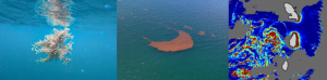
Figure 1: Sargassum macroalgae (left), Sargassum aggregated into raft (center) and algal index from MODIS image (right)
The main task of the engineer will be to improve the current Sargassum detection algorithms and make them operational for implementation in satellite data processing chains (Project Work Package 1). He/she will also be responsible for using satellite data produced by WP1 to produce improved alert bulletins (Work Package 5). Depending on the progress of the work, he/she will be able to contribute to data acquisition (Work Package 2) and use detection products for monitoring (Work Package 3). The skills that are sought concern algorithmic development, data management and processing (remote sensing, model outputs, heterogeneous data) and geomatics issues. Knowledge sharing, networking and distance learning skills will also be appreciated. The recruited person will regularly present his/her work at project progress meetings. It will also contribute to the drafting of activity reports for the project’s funders.
Training and skills required:
Engineering degree or Master 2 in data processing / remote sensing. The candidate should have skills in algorithmics, python coding, risk management and knowledge of business needs. Ability to write and synthesize orally and write. English read, written and spoken.
Gross salary: between 24.5 and 31 k€ annual depending on experience and profile.
Applications (CV and cover letter) must be sent by email to Audrey Minghelli (minghelli@univ-tln.fr) before 24/10/2023.